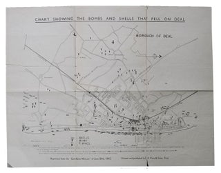
CHART SHOWING THE BOMBS AND SHELLS THAT FELL ON DEAL.
Black & white map, approx. 58 cm. x 44 cm, folded and slightly worn, with a few tears in folds; map annotated indicating a prior owner's home; T. F. Pain & Sons, Deal, Kent, 1945. *Reprinted from the East Kent Mercury of June 30th, 1945. A map of the sites..... More